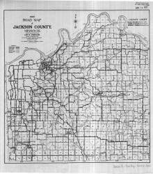
Map shows roads in Jackson County, Missouri. Legend indicates type of road (macadam, graded, etc.), railroads, electric lines, section lines, and streams.
Maps
Displaying 13 - 24 of 42
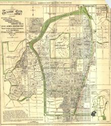
Map of "The Country Club District including Sunset Hill, Mission Hills, Hampstead Gardens, Wornall Manor, Greenway Fields, '1,500 Acres Restricted', Planned, Developed and Offered Exclusively by J. C.

Map of a stretch of the Missouri River from Quindaro Bend and the Fairfax Drainage District to the East Bottoms Bend. Shows all principal topographic features for a minimum distance of 2000 feet inland, indicating levees, jetties, creeks, and railroad lines.
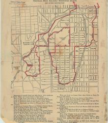
Street map of a "Scenic Route Through the Country Club District: America's Most Beautiful Residential Section, 2000 Acres Restricted." The scenic route is indicated in red; specific directions are at bottom of map. Map shows Kansas City Country Club, Mission Hills Country Club, and names of neighborhoods.
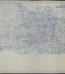
This map of Wyandotte County, KS, shows the land owners on sections in townships 10-12 south, and ranges 23-25 east. It includes the towns of Quindaro, Shawnee, Kansas City, Edwardsville, and Bonner Springs. In addition, roads, railroads, electric railways, schools, churches, cemeteries, streams, and rivers are marked on the map.
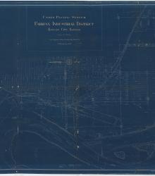
Blueprint map of the Fairfax Industrial District in Kansas City, Kansas, showing Union Pacific Railroad facilities, tracks, and other properties, as well as depicting features of the Missouri and Kansas Rivers and mapping city streets and the rail lines of other companies.
Set of 3 hand-drawn ink-on-linen maps showing the harbor lines for the Kansas River at Kansas City, Kansas, from Turkey Creek to the Argentine Wagon Bridge, showing U. S. Harbor lines, and Kaw Valley Drainage Districts modified lines. Prepared by the Chief Engineer, Drainage Board, for the Kaw Valley Drainage District.

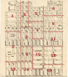
Clipping from the Kansas City Journal on February 28, 1925 depicting the area surrounding the intersection of 15th Street (now Truman Road) and Crystal Avenue where illegal liquors were allegedly unloaded for distribution.
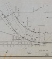
Map depicting locations of railroad lines in the West Bottoms area of Kansas City adjacent to the Stockyards.
Map showing the boundaries of precincts as defined in 1918 for the tenth ward of Kansas City, Missouri. This ward is bounded by 20th Street to the north, Michigan Avenue to the west, 31st Street to the south, and Indiana Avenue to the east.
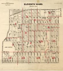
Map showing the boundaries of precincts as defined in 1918 for the eleventh ward of Kansas City, Missouri. This ward is bounded by 20th Street to the north, Grand Avenue (now Grand Boulevard) to the west, 31st Street to the south, and Michigan Avenue to the east.
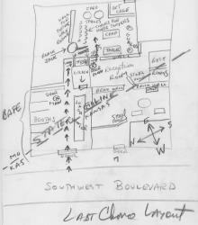
Hand drawn map of the Last Chance Saloon, which was built to span the Missouri/Kansas state line. The entry is located on Southwest Boulevard in Kansas, with gambling taking place behind several doors and upstairs, across the state line in Missouri.