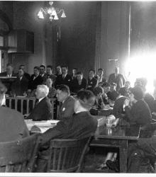
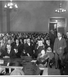
Photograph of spectators in the courtroom at the murder trial of Mrs. Myrtle Bennett. James A. Reed, J. Francis O'Sullivan, defense counsels, and Mrs. Bennett (with hat) "are seated at the counsel table." Mrs. Bennett shot and killed her husband John G. Bennett on September 29, 1929, in a quarrel over a bridge game.
River Market
Displaying 25 - 36 of 88
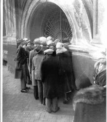
Photograph of a crowd waiting at the locked gate at the criminal court building for the murder trial of Mrs. Myrtle Bennett takes place. Mrs. Bennett shot and killed her husband John G. Bennett on September 29, 1929, in a quarrel over a bridge game. She was acquitted.
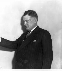
Photograph of Defense Attorney James A. Reed talking to the jury at the murder trial of Mrs. Myrtle Bennett. Mrs. Bennett shot and killed her husband John G. Bennett on September 29, 1929, in a quarrel over a bridge game. She was acquitted.
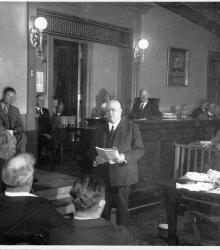
Photograph of James R. Page, county prosecutor, presenting his case before the jury at the murder trial of Mrs. Myrtle Bennett. Mrs. Bennett shot and killed her husband John G. Bennett on September 29, 1929, in a quarrel over a bridge game. She was acquitted.
Photograph of J. Francis O'Sullivan, one of the defense attorneys at the murder trial of Mrs. Myrtle Bennett, summing up the evidence. Mrs. Bennett shot and killed her husband John G. Bennett on September 29, 1929, in a quarrel over a bridge game. She was acquitted.
Photograph of a courtroom scene at the murder trial of Mrs. Myrtle Bennett. She is pictured in the foreground on the far right. Mrs. Bennett shot and killed her husband John G. Bennett on September 29, 1929, in a quarrel over a bridge game. She was acquitted.
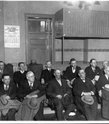
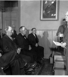
Photograph of the jury of twelve men at the murder trial of Mrs. Myrtle Bennett. Mrs. Bennett shot and killed her husband John G. Bennett on September 29, 1929, in a quarrel over a bridge game. She was acquitted.
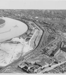
Circa 1930 photograph with an aerial view looking southeast over the Intercity Viaduct and northern part of West Bottoms. Distant view of downtown Kansas City in the top with Quality Hill area and 8th Street Tunnel entrance.
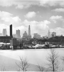
Photograph with view of the downtown skyline from just north of the Missouri River.
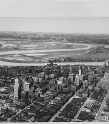
Circa 1930 photograph with an aerial view of downtown Kansas City looking northwest, taken over near 15th Street and Grand Avenue. Shows Missouri River, Municipal Airport, 2nd Hannibal Bridge, and ASB Bridge.
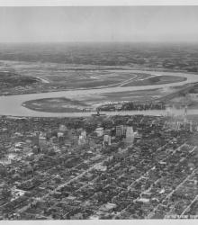
Circa 1930 photograph with an aerial view looking northwest toward downtown Kansas City taken over near 18th and Harrison streets. Shows the confluence of the Kansas and Missouri Rivers, Municipal Airport, and Fairfax area.

Map of a stretch of the Missouri River from Quindaro Bend and the Fairfax Drainage District to the East Bottoms Bend. Shows all principal topographic features for a minimum distance of 2000 feet inland, indicating levees, jetties, creeks, and railroad lines.