
Postcard looking west towards the intersection of 45th Street and Rockhill Road. Pictured in the left background in Oak Hall, the estate of William Rockhill Nelson, once located south of 45th Street between Oak Street and Rockhill Road.
Rockhill
Displaying 13 - 20 of 20
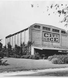
Circa 1930 photograph with full frontal view of City Ice Company of Kansas City, Plant No. 53, built in 1919. It was located on the west side of Oak Street between 48th Street and 49th Street. This property was situated just north of Brush Creek before the waterway was diverted to its current location.
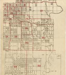
Map showing the boundaries of precincts as defined in 1918 for the thirteenth ward of Kansas City, Missouri. This ward is bounded by 35th Street to the north, Campbell and Troost Avenue to the west, south city limits to the south, and eastern city limits to the east.
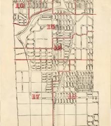
Map showing the boundaries of precincts as defined in 1918 for the fourth ward of Kansas City, Missouri. This ward is bounded by 39th Street to the north, Kansas to the west, south city limits to the south, and Campbell Street and Troost Avenue to the east.
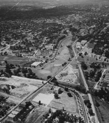
An aerial view of the Country Club Plaza in 1925, looking north-northwest near Brookside Boulevard and 51st Street.
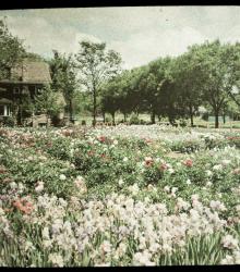
An autochrome photograph of George Cope's "Rainbow" Garden of peonies, iris, and poppies, taken looking north. Cope was co-owner of Cope & Sons, a carpentry company. This property was situated on the west side of Oak Street, just north of Brush Creek before the waterway was diverted to its current location.
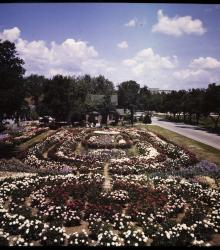
A color glass plate positive photograph of George Cope's "Rainbow" Garden of peonies, iris, and poppies. This vantage point faces north with Oak Street on the right, Cope's residence in the center background, and the Nelson Gallery of Art (Nelson-Atkins Museum of Art) in the far right background.
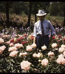
A color glass plate positive photograph of George Cope in his "Rainbow" garden of peonies, iris, and poppies. Cope was co-owner of Cope & Sons, a carpentry company. This property was situated on the west side of Oak Street, just north of Brush Creek before the waterway was diverted to its current location.