Letter from James A. Reed to Tom Pendergast regarding a conversation with Joe Shannon about Mr. Kingsley (probably George Kingsley).
The State Historical Society of Missouri-Kansas City
Displaying 73 - 84 of 287
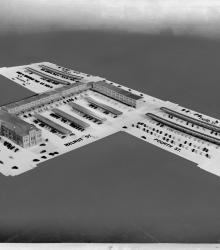
Architect's model of the New Municipal Market which was planned to be completed in 1938 on the grounds of the demolished City Hall and Market.
Letter from James A. Reed to Tom Pendergast asking him to give consideration to J. J. Brink.
A collection of newspaper article reproductions concerning Kansas City's Ten-Year Plan. Most of these Kansas City Star and Kansas City Times articles of 1929-1931 detail Conrad H. Mann's work with the Ten-Year Plan.
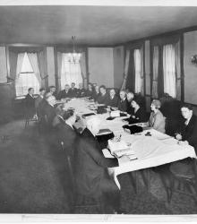
Executive committee at work in preparation of the Ten Year Plan in Kansas City.
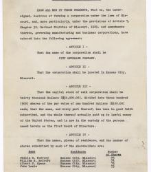
Articles of Agreement of City Beverage Company, Kansas City, Missouri. The document defines the company's capital stock, shares, and term length. The shareholders and board of directors are listed as Philip H. McCrory, William H. McCrory, Albert P. Spaar, and John Lazia. The articles then list the five purposes of the company.
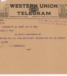
Telegram from Tom Pendergast to Senator James A. Reed regarding "the Franklin matter."
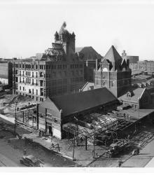
Old municipal market and city hall in the process of being torn down for a new municipal market. This vantage point faces northwest from the intersection of 5th Street and Walnut Street.
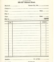
Blank order form for the T.J. Pendergast Wholesale Liquor Co. at 525-527 Delaware Street, Kansas City, Missouri.
Letter from Bennett C. Clark to James A. Reed. Clark discusses a Redistricting Bill and asks Reed to ask for Thomas J. Pendergast's input on the matter.
Series of articles from the Kansas City Star entitled "What Kansas City Is to Get for Its Ten-Year Plan Money". It details each proposition to be voted upon in the May 26, 1931 election.
Letter from James A. Reed to Tom Pendergast regarding Judge C. C. Dickinson's position on the Eighteenth Amendment, and remarks that he thinks "you can trust him to go along and get rid of thise prohibition nuisance."