Map showing the boundaries of precincts as defined in 1918 for the fourth ward of Kansas City, Missouri. This ward is bounded by 39th Street to the north, Kansas to the west, south city limits to the south, and Campbell Street and Troost Avenue to the east.
Board of Election Commissioners (Kansas City, Mo.)
Displaying 1 - 12 of 16
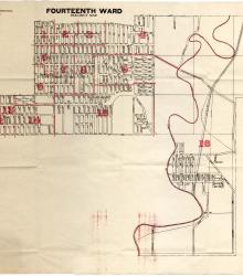
Map showing the boundaries of precincts as defined in 1918 for the fourteenth ward of Kansas City, Missouri. This ward is largely bounded by 23rd Street to the north, Indiana Avenue to the east, 35th Street to the south, and sections east of Blue River bounded by the eastern city limits to the east.
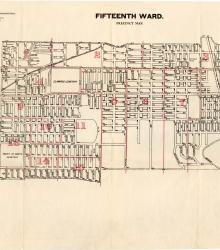
Map showing the boundaries of precincts as defined in 1918 for the fifteenth ward of Kansas City, Missouri. This ward is largely bounded by 9th Street to the north, Cleveland Avenue to the west, 23rd Street to the south, and eastern city limits to the east.
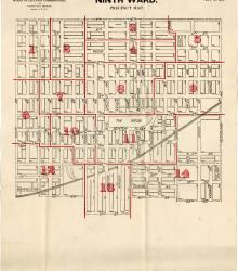
Map showing the boundaries of precincts as defined in 1918 for the ninth ward of Kansas City, Missouri. This ward is bounded by 9th Street to the north, Euclid Avenue to the west, 20th Street to the south, and Cleveland Avenue to the east.
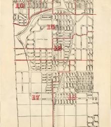
Map showing the boundaries of precincts as defined in 1918 for the tenth ward of Kansas City, Missouri. This ward is bounded by 20th Street to the north, Michigan Avenue to the west, 31st Street to the south, and Indiana Avenue to the east.
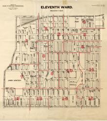
Map showing the boundaries of precincts as defined in 1918 for the eleventh ward of Kansas City, Missouri. This ward is bounded by 20th Street to the north, Grand Avenue (now Grand Boulevard) to the west, 31st Street to the south, and Michigan Avenue to the east.
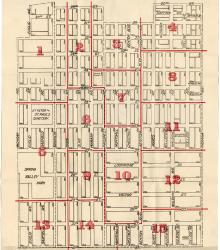
Map showing the boundaries of precincts as defined in 1918 for the sixth ward of Kansas City, Missouri. This ward is bounded by 9th Street to the north, Grand Avenue (now Grand Boulevard) to the west, 20th Street to the south, and Harrison Street to the east.
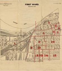
Map showing the boundaries of precincts as defined in 1918 for the first ward of Kansas City, Missouri. This ward is bounded by the Missouri River to the north, Kansas to the west, 14th Street to the south, and Grand Avenue (now Grand Boulevard) to the east.
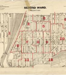
Map showing the boundaries of precincts as defined in 1918 for the second ward of Kansas City, Missouri. This ward is bounded by 14th Street to the north, Kansas to the west, 24th Street to the south, and Grand Avenue (now Grand Boulevard) to the east.
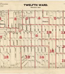
Map showing the boundaries of precincts as defined in 1918 for the twelfth ward of Kansas City, Missouri. This ward is bounded by 31st Street to the north, Main Street to the west, 39th Street to the south, and Garfield Avenue to the east.
Map showing the boundaries of precincts as defined in 1918 for the third ward of Kansas City, Missouri. This ward is bounded by 24th Street to the north, Kansas to the west, 39th Street to the south, and Main Street to the east.
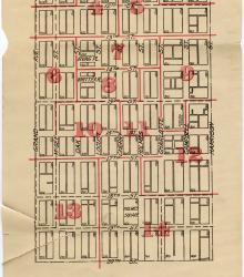
Map showing the boundaries of precincts as defined in 1918 for the eighth ward of Kansas City, Missouri. This ward is bounded by 9th Street to the north, Harrison Street to the west, 20th Street to the south, and Euclid Avenue to the east.