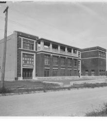
Photograph of the E. F. Swinney School, located on the north side of 47th Street between Holly Street and Jarboe Street. The school was named for Edward F. Swinney, treasurer of the Board of Education, 1894 to 1904. This vantage point faces northeast from the south side of 47th just east of Holly.
West Plaza
Displaying 1 - 8 of 8
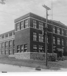
Photograph of the E. F. Swinney School, located on the north side of 47th Street between Holly Street and Jarboe Street. The school was named for Edward F. Swinney, treasurer of the Board of Education, 1894 to 1904. This vantage point faces northwest from the intersection of 47th and Jarboe.
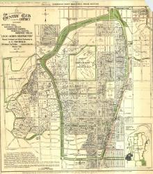
Map of "The Country Club District including Sunset Hill, Mission Hills, Hampstead Gardens, Wornall Manor, Greenway Fields, '1,500 Acres Restricted', Planned, Developed and Offered Exclusively by J. C.
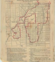
Street map of a "Scenic Route Through the Country Club District: America's Most Beautiful Residential Section, 2000 Acres Restricted." The scenic route is indicated in red; specific directions are at bottom of map. Map shows Kansas City Country Club, Mission Hills Country Club, and names of neighborhoods.

Circa 1925 photograph of the Sunset Hill Line streetcar looking south from the intersection of 48th Street and Belleview Avenue. The streetcar's bridge over Brush Creek, Ward Parkway, and Sunset Hill are pictured in the background.
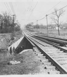
Circa 1925 photograph of the Sunset Hill Line streetcar bridge over Brush Creek. This vantage point faces north up Belleview Avenue towards its intersection with 48th Street in the background.
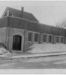
Circa 1925 photograph of Grace English Lutheran Church in the winter at the southeast corner of 43rd Street and Madison Avenue. Part of the Ohio Synod and dedicated October 9, 1921. This vantage point faces south-southwest from the north side of 43rd Street between Madison Avenue and Summit Street.
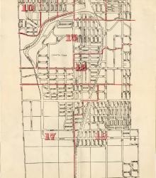
Map showing the boundaries of precincts as defined in 1918 for the fourth ward of Kansas City, Missouri. This ward is bounded by 39th Street to the north, Kansas to the west, south city limits to the south, and Campbell Street and Troost Avenue to the east.