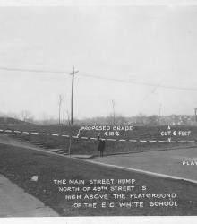
Photograph with caption, "The Main Street hump north of 49th Street is high above the playground of the E. C. White School. The picture shows a proposal to cut 6 feet of elevation of Main Street to a grade of 4.18%. This vantage point faces northwest from the north side of 49th Street between Main Street and Walnut Street.
South Plaza
Displaying 1 - 12 of 45
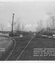
Photograph with caption, "proposed extension of Brookside Boulevard north to connect with Main at 41st Street." At the time, Brookside Boulevard was to be extended north until 41st Street were it would meet with Main Street. The Country Club Car Line, Ponce de Leon Hotel, 47th Street, St.
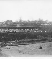
Photograph with caption, "The former brickyard and rock quarry south of Brush Creek and west of Main Street." This vantage point faces south from near the intersection of Wyandotte Street and Ward Parkway and shows annotations labeling Brush Creek and street intersections.
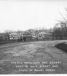
Photograph with caption, "The old brickyard and quarry west of Main Street and south of Brush Creek." This vantage point faces south on Baltimore just north of its intersection with Ward Parkway. The photograph's annotations label street intersections and show proposed road improvements.
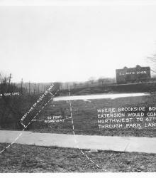
Photograph with caption, "where Brookside Boulevard Extension would come northwest to 47th Street through Park Land." This vantage point faces south from just south of the intersection of Main Sreet and 47th Street.
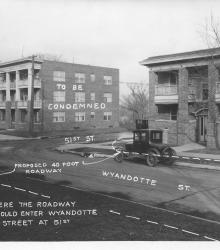
Photograph with caption, "Where the roadway would enter Wyandotte Street at 51st." This vantage point faces northeast from near the intesection of Wyandotte and 51st. The photograph's annotations label streets and show proposed road improvements.
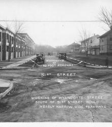
Photograph with caption, "widening of Wyandotte Street south of 51st Street would merely narrow wide parkways." This vantage point faces south on Wyandotte Street from just north of 51st Street. The photograph's annotations label streets and show proposed road improvements.
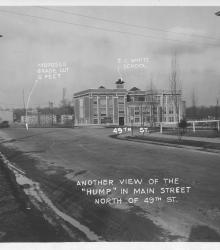
Photograph with caption, "Another view of the 'hump' in Main Street north of 49th St." This vantage point faces north-northeast on the west side of Main Street just south of 49th Street.
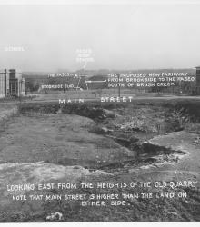
Photograph with caption, "looking east from the heights of the old quarry. Note that Main Street is higher than the land on either side."
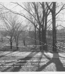
Photograph with caption, "looking south from Brush Creek Boulevard [presently Emanuel Cleaver II Boulevard] the proposed trafficway, on park lands, to widened East 48th Street." This vantage point faces south-southeast from just south of Brush Creek Boulevard near its intersection with the Country Club Car Line.
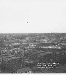
Photograph with caption, "looking southwest from the roof of Sophian Plaza" at the northwest corner of Warwick Boulevard and Brush Creek Boulevard (presently Emanuel Cleaver II Boulevard). The Country Club Car Line and E.C. White School (center background) are pictured.
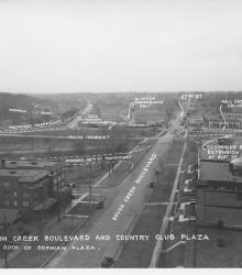
Photograph with caption, "Brush Creek Boulevard and Country Club Plaza [looking west] from roof of Sophian Plaza." The annotations on the photogaph label streets and show proposed road improvements.