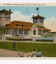
Postcard showing the Swope Park Shelter House Number 1, located to the southeast of the main entrance to Swope Park in Kansas City, Missouri. This vantage point faces southeast on Meyer Boulevard just east of the Swope Park west entrance. The back of the postcard includes a short letter to Annette Party of Jefferson City, Missouri.
Pedestrians
Displaying 61 - 72 of 73
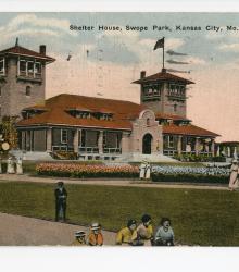
Postcard showing the Swope Park Shelter House Number 1, located to the southeast of the main entrance to Swope Park in Kansas City, Missouri. This vantage point faces southeast on Meyer Boulevard just east of the Swope Park west entrance. The back of the postcard includes a short letter to Mr. and Mrs. H. C. Meyers of Belleville, Illinois.
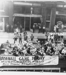
People waving U.S. flags on top of double-decker bus headed north on Main Street as part of a "baseball parade." The sign on the bus reads: Baseball Game Today, Muehlebach Field, Mercy Hospital - K.C. Orphans Boys' Home. This vantage point faces west-southwest towards the Hotel Stag at 414 Main Street. Source: Bernard Ragan.
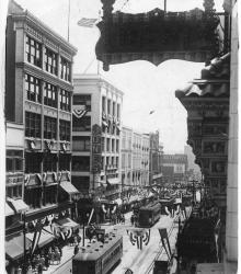
The intersection of Main Street and 12th Street decorated with patriotic banners and flags for the 1928 Republican National Convention at Convention Hall in Kansas City, Missouri. This elevated vantage point faces south on Main Street towards the intersection of 12th and Main from just south of 11th Street.
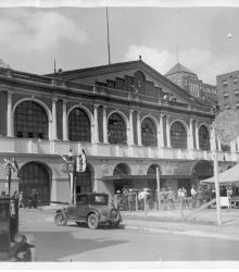
Exterior of the Convention Hall that housed the 1928 National Republican Convention in downtown Kansas City, Missouri. This hall was once located on the north side of 13th Street between Wyandotte Street and Central Street. It was razed after the completion of the Municipal Auditorium in 1935.
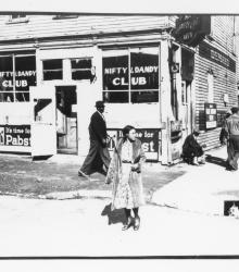
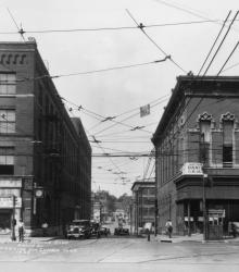
Exterior of Nifty and Dandy Club at the northeast corner of 14th Street and Highland Avenue, Kansas City, Missouri, no date. This vantage point faces east-northeast from the intersection of 14th and Highland. Source: Frank Driggs.
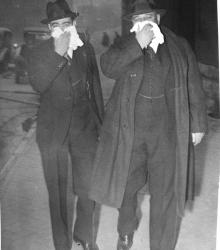
Dust Bowl period photograph of two pedestrians in Kansas City during a dust storm at noon on March 21, 1935. These dust storms caused an estimated one billion dollars in damages.
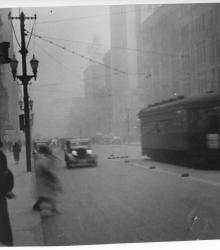
Dust Bowl period photograph of Grand Avenue from 10th Street in Kansas City during a dust storm at noon on March 21, 1935. This vantage point faces south-southwest on Grand Avenue (now Grand Boulevard) from just south of 10th Street. W. W. Kimball Pianos is pictured to the left at 1009 Grand Avenue.
Street scene showing the Kansas City Public Service Company Building (also known as the Kansas City Railway Company or K.C. Rys. Co. from 1914-1925) on the left. This building was located on the south side of 15th Street (now Truman Road) between Grand Avenue (now Grand Boulevard) and Walnut Street.
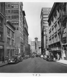
Looking north along Baltimore Avenue, 9th to 11th Streets, with the New York Life Building in the center.
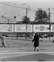
This photograph of the Southeast Side Business District was taken looking southeast from the intersection of Prospect Avenue and 18th Street in Kansas City, Missouri. Pictured are four Merritt Outdoor Advertising Company billboards. 18th & Prospect Drugstore and stores located on two of the other corners.
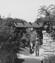
Two residents, a man and a woman, of Greenway Fields walk near the Rams' Heads, a decorative motif for a trellis over the sidewalk on Valley Road near 62nd Street. This vantage point faces north-northeast on Valley Road south of 62nd Street.