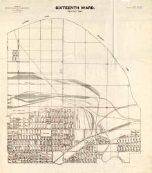
Map showing the boundaries of precincts as defined in 1918 for the sixteenth ward of Kansas City, Missouri. This ward is bounded by the Missouri River to the north, Monroe Avenue to the west, 9th Street to the south, and eastern city limits to the east.
Maps
Displaying 13 - 21 of 21

Map showing the boundaries of precincts as defined in 1918 for the seventh ward of Kansas City, Missouri. This ward is bounded by the Missouri River to the north, Lydia Avenue to the west, 9th Street to the south, and Monroe Avenue to the east.
Map showing the boundaries of precincts as defined in 1918 for the thirteenth ward of Kansas City, Missouri. This ward is bounded by 35th Street to the north, Campbell and Troost Avenue to the west, south city limits to the south, and eastern city limits to the east.
Map showing the boundaries of precincts as defined in 1918 for the fourth ward of Kansas City, Missouri. This ward is bounded by 39th Street to the north, Kansas to the west, south city limits to the south, and Campbell Street and Troost Avenue to the east.
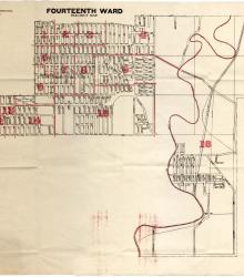
Map showing the boundaries of precincts as defined in 1918 for the fourteenth ward of Kansas City, Missouri. This ward is largely bounded by 23rd Street to the north, Indiana Avenue to the east, 35th Street to the south, and sections east of Blue River bounded by the eastern city limits to the east.
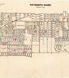
Map showing the boundaries of precincts as defined in 1918 for the fifteenth ward of Kansas City, Missouri. This ward is largely bounded by 9th Street to the north, Cleveland Avenue to the west, 23rd Street to the south, and eastern city limits to the east.
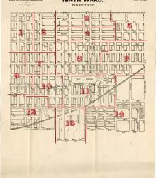
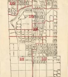
Map showing the boundaries of precincts as defined in 1918 for the ninth ward of Kansas City, Missouri. This ward is bounded by 9th Street to the north, Euclid Avenue to the west, 20th Street to the south, and Cleveland Avenue to the east.
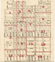
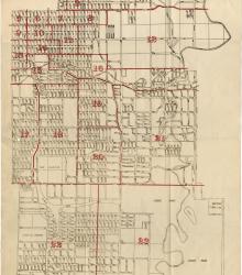
Map showing the boundaries of precincts as defined in 1918 for the tenth ward of Kansas City, Missouri. This ward is bounded by 20th Street to the north, Michigan Avenue to the west, 31st Street to the south, and Indiana Avenue to the east.
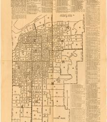
Map printed in The Missouri Democrat on June 25, 1926, showing the latest official district, ward, and precinct lines for Kansas City, MO as rearranged under a recent charter. Included with the map is the voting booth location for each precinct.